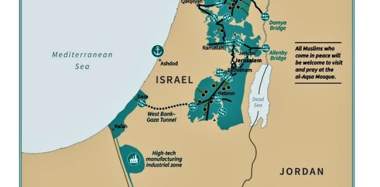
Donald Trump released, on Tuesday evening, a map through his Twitter page, showing the borders of the "Palestinian state" whose borders were demarcated according to the "Deal of the Century".
Trump tweeted in Arabic, while publishing a picture of the map, saying, "This is what the future state of Palestine might look like with a capital in parts of East Jerusalem."
"All Muslims who come peacefully to pray at the Al-Aqsa Mosque are welcome," read the map.
The map shows the establishment of industrial zones, as well as a tunnel linking Gaza to the West Bank.
Jared Kouchner, architect of the "Deal of the Century", told Al Jazeera that the map that was drawn was inspired by the UN Charter 242.
He pointed out that the "Deal of the Century" plan gives everyone the freedom to pray at the Al-Aqsa Mosque and guarantees a Palestinian state connected to the lands.
He claimed that the Jerusalem municipality boundaries have changed since 1967 until now. Noting that the plan gives Israel the opportunity to enjoy more security in the region
.
He said, "We took our time to map the solution and the Palestinian areas will be connected to each other by tunnels and bridges."
"The map that we drew is in line with the UN resolution, and we do not want to uproot any Jew or Palestinian in the area," he added.
He continued, "Any solution based on the two countries must be based on the map that we have drawn."